In addition to our existing research projects, we expand the research inactive rift basins
and start two new initiatives; one is the beginning of a petrographic data base and the
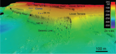
second multidisciplinary study of a cores from a lowstand fringing reef offshore
Mozambique that grew during the last glacial maximum. With the help of ENI, these cores
were made available to us. This core analysis will be a major focus in our shallow-water
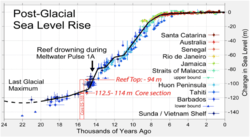
carbonate theme. The fringing reef drowned during the deglaciation and was never
subaerially exposed. Thus, these cores carry a unique record of the Indian Ocean during
the last glacial maximum and giving us the opportunity to study unaltered marine
cementation in a reefal system. In the first year, the focus will be on core description,
stratigraphy, and preliminary chemical and petrophysical analysis.
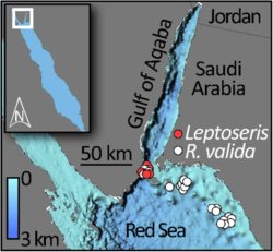
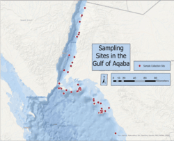
Our studies in active rift basins in the Red Sea and the Gulf of Aqaba are ongoing with
a focus on the lowstand sterilization hypothesis in the Red Sea rift brine pools. The Gulf of
Aqaba is an unusual warm basin that can be compared to the Cretaceous oceans.
Composition and diagenesis of samples from the deep slope will be analyzed and examined
for their difference to “normal” cold ocean slope samples.